Introduction and Background
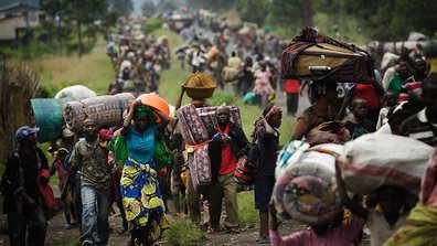
Uganda has been hosting an average of 161,000 refugees per year since 1961. The country signed the legal document that defined who is considered a refugee at the 1951 Refugee Convention and proceeded to sign the 1967 Protocol that removed geographical and temporal restrictions that were part of the original Convention. In 2006, Uganda implemented a progressive Refugee Act that recognized the right of the country’s refugees to work, move around the country, and live in the community. This differed greatly from previous restrictions, which relegated refugees to life in rural settlements with no access to work opportunities and community interaction.
Table 1 below shows the country of origin of refugees in Uganda as of February 28, 2014 (UNHCR Uganda Fact Sheet, 2014). The three largest populations of concern are refugees and asylum seekers originating from the Democratic Republic of the Congo (DRC), South Sudan, and Somalia. Major cities of conflict in the DRC are North Kivu and Province Orientale; attacks on the citizens of these cities have resulted in a major influx of Congolese into the south and midwest region of Uganda. In 1989, refugees from South Sudan fled the prolonged conflict between the Sudanese Government and the Sudan People’s Liberation Army and entered Uganda. Today, South Sudanese refugees are seeking safety in the West Nile area of Uganda from local clashes and inter-tribal violence in their home country. Refugees from Somalia are fleeing from the insecure central and southern regions.
Table 1 below shows the country of origin of refugees in Uganda as of February 28, 2014 (UNHCR Uganda Fact Sheet, 2014). The three largest populations of concern are refugees and asylum seekers originating from the Democratic Republic of the Congo (DRC), South Sudan, and Somalia. Major cities of conflict in the DRC are North Kivu and Province Orientale; attacks on the citizens of these cities have resulted in a major influx of Congolese into the south and midwest region of Uganda. In 1989, refugees from South Sudan fled the prolonged conflict between the Sudanese Government and the Sudan People’s Liberation Army and entered Uganda. Today, South Sudanese refugees are seeking safety in the West Nile area of Uganda from local clashes and inter-tribal violence in their home country. Refugees from Somalia are fleeing from the insecure central and southern regions.
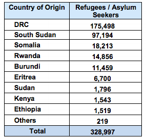
Table 1. Country of Origin of Refugees and Asylum-Seekers in Uganda (Thousands).
Source: UNHCR Uganda Fact Sheet, 2014. Current as of Feb. 2014.
Project Objectives
This project had several objectives in order to determine the best sites for refugee placement.
The first objective of the project was to develop two separate scenarios for refugee campsite selection.
Scenario 1: Existing Community Infrastructure, was designed such that the selection of sites would assume that refugees would be reliant on the community infrastructure that already exists. This would provide refugees an opportunity to integrate with local communities to a certain extent, and put less pressure on UNHCR to develop the infrastructure for new camps in rapid crisis situations.
Scenario 2: New Community Infrastructure, was designed under the assumption that UNHCR would be able to provide infrastructure to new camps. Although both models aspire to a level of community integration, this model would be undertaken under the hope that the presence of UNHCR and thus, refugees, would actually benefit communities that had previously suffered from poor access to certain resources. These camps might prove a bit more difficult to develop, but the hope is that the positive effects of a camp would benefit the communities for a long time to come.
Our second objective was to use GIS to develop a methodology for ENNEAD Architects, in partnership with UNHCR, to determine the best locations for refugee camps and settlements in Uganda based on both environmental and social factors.
Our third objective was to use the methodology created to determine the best sites for refugee placement, and to determine ways that this methodology could be used in other countries and humanitarian emergencies.
Study Area
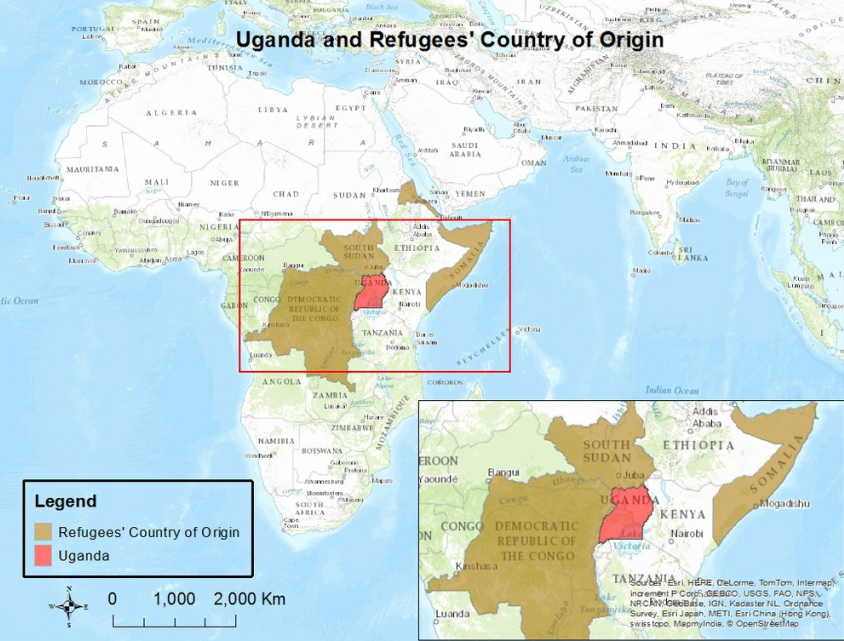
Our study focuses on determining the best locations to build refugee camps in Uganda. As mentioned in the introduction, the three largest refugee populations of concern are originating from the Democratic Republic of the Congo, South Sudan, and Somalia. Below you will find our locator map.
Data Sources
Our group compiled data from several sources in order to complete our analysis, we have included information about each of those sources below for reference.
Methods
Factor Selection
A list of both environmental and social factors that play important roles in site selection for building a refugee camp were created. Based on the available datasets, sixteen factors were chosen to conduct an analysis on. Other data could have proven helpful, but the project is limited by the amount of data about Uganda that is currently available.
A list of both environmental and social factors that play important roles in site selection for building a refugee camp were created. Based on the available datasets, sixteen factors were chosen to conduct an analysis on. Other data could have proven helpful, but the project is limited by the amount of data about Uganda that is currently available.
|
Environmental Factors:
1. Distance to Water 2. Flood Risk 3. Drought Risk 4. Interannual Water Variability 5. Safe Water Coverage 6. Elevation 7. Slope 8. Landuse 9. Soil Type - Food Suitability |
Social Factors:
10. Population Density 11. Poverty Density 12. Distance from Borders 13. Distance to Roads 14. Distance to Health Centers 15. Distance to Education Facilities 16. Distance to Towns |
Data Reclassification
In order to complete our analysis, it was important that the data be organized in a way that made them comparable. Data about the number of people per square kilometer in a district is not directly comparable to data about average rainfall in the same district. We created a ranking system from 1-10 and reclassified all of our data into that system, with 10 representing the most optimal conditions, and 1 representing the least. Some conditions were such that we chose to remove them entirely from the analysis because it would be impossible to build a refugee camp there. Those values are ranked as "masked" or "NIL". (Data Table not available on Mobile)
Masking Out Unsuitable Locations
Creating a mask means indicating to the GIS program that a certain area should be removed from analysis. Essentially, we are creating blind areas for the program to ignore. As shown in the reclassification table above, some areas within the geographical boundaries of Uganda were deemed completely unsuitable for refugee placement. The table below outlines the factors that had masked values and the reasons for each value being masked. (Data Table not available on mobile)
|
Factor
Flood Risk Soil Type Slope Landuse |
Masked Value
"Extremely High" Peat >25% Lakes, Rivers, National Parks, Hunting Reserves, Game Reserves |
Reason for Mask
Because infrastructure for refugee camps is often composed of tents and other transient structures, locations with high flood risks would pose a great danger to refugees in such areas, and would create a great challenge for UNHCR to constantly adapt to changing conditions due to flooding. Peat soil is unsuitable for building and farming, and would thus make it difficult to create viable settlements on such land. Areas with a slope greater than 25% would be challenging to build on, and also create dangers for people living in those areas. For environmental, legal, and conservation reasons, these areas were deemed unsuitable for settlement building. |
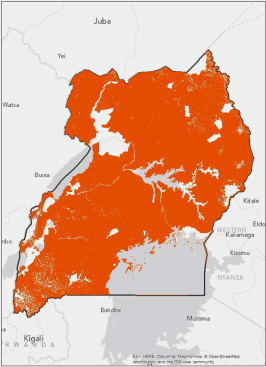
Orange represents the suitable areas considered in the analysis.
Weighting Factors
The factors we view as the most important when considering site selection for a refugee camp are the distance to water, the flood risk, and the slope. Having access to water is one of the first priorities because it is needed to sustain life. If there is no water available in an area, it is unsuitable to build a camp there. Uganda experiences frequent floods, and these natural disasters not only endanger the lives of people, but they also destroy infrastructure. Thus, it is important not to build a camp in high flood risk areas. Slope is given a high weight because structures can only be built on a specific range of slope gradients or else the foundation of the structure will be extremely unstable. The next most important factors are the distances one must walk to reach roads and health centers, followed closely by the distance to education facilities. Having walkable access to roads, health centers and schools is crucial because refugees typically have no means of transportation besides walking, and there is a certain threshold in which people are willing and capable of walking.
Drought risk was given a lower weighting factor than flood risk because the drought data only provided two categories of risk for Uganda and the entire country was almost uniform, thus the factor did not provide too much information. Safe Water Coverage similarly was given a low weight because it did not provide precise information for all locations in Uganda since the data was broken down into district. This meant that each district was assumed to have the same safe water coverage which is not always the case. Elevation was given a low weight because the weather conditions in Uganda are neutral and do not change drastically at higher elevations.
The only changes we made in the weighting of factors from Scenario 1 to Scenario 2 was lowering the weight for distance to health centers and education centers, and raising the weight of poverty density. In Scenario 2 we are assuming that the UNHCR will be willing to build new schools and health centers, which is why the distance to the current facilities are not as important. The poverty density plays a greater role in this scenario because the goal is to help not only the refugees, but also the Ugandan citizens who could are currently without some aspects of social infrastructure. The remaining factors kept the same weight.
Raster Calculator:
All sixteen factors were combined together using the formula below to create a map that shows the best locations to build a refugee camp in Uganda. By assigning weights to the factors, the map with the 16 factors compiled together will have a score from 1-10 for every 0.5 square kilometer in Uganda that was not initially masked out.
(Population Density*.05) +(Poverty Density*0.05) +(Distance to Towns*0.025) +(Distance to Water*0.15) +(Distance to Roads*0.075) +(Distance to Health Centers*0.075) +(Distance to Education Facilities*0.05) +(Soil Type*0.025) +(Flood Risk*0.15) +(Drought Risk*0.05) +(Interannual Water Risk*0.025) +(Elevation*0.025) +(Slope*0.15) +(Safe Water Coverage*0.025) +(Distance from Borders*0.025) +(Landuse*0.05)
= Scenario 1 Raster
Scenario 2 was calculated in a similar way as Scenario 1, except the weights and classifications for some of the factors changed.
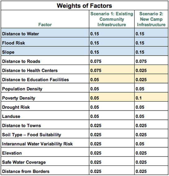
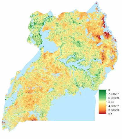
Results
|
Scenario 1: Existing Community Infrastructure
|
Scenario 2: New Camp Infrastructure
|
These are the final maps for our two scenarios. The distinct difference between the two maps is evidence of a successful methodology. The green to red color scale indicates a spectrum of good to bad areas to build camps. It is important to note that while we ranked each factor on a scale of 1-10, our lowest value was 2.1 and our highest was 8.275, indicating that no location is perfect and no location is without some benefits.
Conclusion
We conclude that the methodology created in this project was successful in determining the optimal site selection for refugee camps in Uganda based on the two distinct scenarios. As shown in the map results for the two scenarios, there are some areas that appear to have the same suitability score for each scenario, and other areas that have different scores for the existing community infrastructure scenario and the new camp infrastructure scenario. This is the case because only some of the factors changed classification between the two scenarios. For example, all of the environmental factors, such as flood risk, had the same classification and it was only the social factors, such as distance to education facilities, that changed.
This methodology can easily be applied to other countries. One unique thing about the project is that the methodology is flexible and it allows an analyst to decide which factors to include, how to classify each factor, and what weight each factor should receive when deciding on the optimal locations. Any of those three steps can be altered and the analyst will get a different result.
Not only can this project help with creating new refugee camps, but it also provides an opportunity to analyze current camps worldwide. Analysts can investigate different refugee camps using the methodology created and see which factors play an important role in making a refugee camp location a good or poor site. For example, one may find out that an existing refugee camp is optimal in terms of distance to health facilities, but has a poor score in terms of the soil suitability for growing crops. This information can help aid organizations, such as UNHCR, learn from previous camps that have been built.
next steps
Future steps for this project would include inviting experts to provide more analysis and details on factors, which would allow different types of data to be used in the selection of optimal site locations for refugee camps. A limitation of this project is that we did not have expertise in all the factors we wanted to include in our analysis. One example is that we wanted to include a factor on the soil suitability for building stable structures. Data of the various soil types existing in Uganda is available, however an expert is needed to interpret the data and classify each soil type by its suitability for building infrastructure on it.
Experts would also be able to improve this project by providing more social analysis, such as the language, ethnicity, and religious affiliation break downs of a country. This would help with camp site selection by determining if there will be any social conflicts between the hosting community and the refugees, and by attempting to place refugees of the same language or religion together.
We hope that this methodology can be applied to other countries and serve as a useful tool for policy makers and humanitarian groups.
Presentation of methodology and findings
Final report
| gisfinalreport1.pdf |
